Elevation Certificates
As counties have performed flood studies and FEMA has subsequently updated their FIRMs, I have been called upon to perform more Elevation Certificates. There are questions that tend to arise and I hope the following can answer some of these.
Definitions:
- FEMA – Federal Emergency Management Agency
- FIRM – Flood Insurance Rate Map
- Elevation Certificate – A form required by FEMA for the reduction of flood insurance rates.
- Special Flood Hazard Area – An area designated upon a FIRM as prone to flooding
- Zone A – A designation for a special flood hazard area identified as prone to flooding but lacking the in-depth flood study required to establish flood elevations.
- Zone AE – A designation for a special flood hazard area where flood studies have been performed and base flood elevations have been established.
- Base Flood Elevation – An altitude set as the maximum elevation that a flood event will reach
- 100-year Flood – Area with a 1% chance of flooding with every Precipitation Event
- 500-year Flood – Area with a 0.5% chance of flooding with every Precipitation Event
- LOMA – Letter of Map Amendment
“A Letter of Map Amendment (LOMA) is an official amendment, by letter, to an effective National Flood Insurance Program (NFIP) map. A LOMA establishes a property’s location in relation to the Special Flood Hazard Area (SFHA). LOMAs are usually issued because a property has been inadvertently mapped as being in the floodplain, but is actually on natural high ground above the base flood elevation” (www.fema.gov). - Flood Vent – A permanently opening (or self-opening) located within one foot of the ground to allow the free flow of flood waters in and out of a crawlspace or foundation.
- Finished Floor Elevation – (FFE) The elevation of a floor that is finished (and heated) within a structure
- Lowest Adjacent Grade – (LAG) The lowest elevation immediately adjacent to the foundation of a structure
- Highest Adjacent Grade – (HAG) The highest elevation immediately adjacent to the foundation of a structure
Links
- FEMA Map Service Center
- National Flood Insurance Program Elevation Certificate and Instructions
- Knoxville Geographic Information System (KGIS)
- Tennessee Property Viewer
Elevation Certificates
When acquiring flood insurance, it is probable that you will be required to get an elevation certificate. These are used by FEMA to assist in establishing the rates for flood insurance. Typically, an elevation certificate must be completed by and engineer, architect, or a land surveyor.
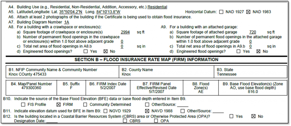
Sections A & B
These sections must be completed for every elevation certificate.
- Latitude and longitude can be acquired from the Tennessee Property Viewer (NAD 1983)
- Building Diagram is located in the instructions
FIRM information can be obtained from the FEMA Map Center. Here, you can search for you address (deselect the Map-based Search). Click on the Globe with the Magnifying glass icon to view the corresponding map. From this Viewer, a person can zoom and pan as needed. Once the preferred area is found, clicking on the “Make a FIRMette” button will allow you to make a printable map with the appropriate title information necessary to complete an Elevation Certificate. (click and drag the pink box to the desired location and choose to create FIRMette as either a PDF or an image)
Zone AE
When a property lies within an AE zone, it has an established base flood elevation. A surveyor locates the elevations of the structure relative to a known benchmark. He then completes Sections A-D of the Elevation Certificate as well as provides pictures of the front and rear of the structure.
Section C2
 This section shows the elevation of the various points at the structure. Typically, FEMA prefers to see all of the numbers above the Base Flood Elevation. As long as the FFE or lowest heated floor is above (preferred to be 1 foot above) the BFE, a discount should be applied. If all of the elevations are above the BFE, it may be possible to request a LOMA.
LOMA
By requesting (and ultimately granted) a LOMA, a structure may have the lender’s requirement of flood insurance removed. A property must have a base flood elevation to request a LOMA. If the property is not in an AE zone, an engineer may be engaged to perform an independent flood study to establish the Base Flood Elevation. Beware, this is a labor intensive proceeding and WILL be expensive. The benefit might be worth the expense if it can significantly lower or remove the flood insurance premiums.
Zone A
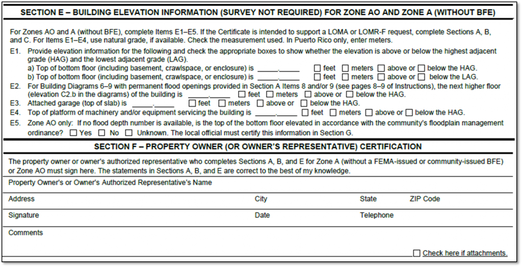
If the subject property is located within an A zone, it does not have a base flood elevation. Therefore, section C cannot be completed. I have recently been told that zone A property need not have an elevation completed by a surveyor. If the property is in this situation, the property owner or representative can complete the elevation certificate.
In addition to completing Sections A and B, the property owner will also complete Sections E and F. Section E requires the property owner to measure the difference between the Highest and Lowest Adjacent grades and the bottom floor or crawlspace. If the structure has flood vents, they must also note the elevation difference with between the next higher floor and the Highest Adjacent Grade. Additionally, they must also compare the HAG to the garage and the lowest machinery, such as the external HVAC heat exchanger, with Hvac installation services you can find online.
.
Note:
It is recommended that the elevation difference between the highest adjacent grade and the finished floor must be at least 2 foot in order to receive any significant discount in insurance premiums (as told to me by insurance agents). It is also recommended that the ratio of flood vent area to crawlspace area be 1 in² to 1 ft².
As with most governmental forms, leave no space (in a section you should be completing) unfilled. Use N/A if needed.


